 |
| After 2 days of rain this was our morning when we started out on the 'W' in TdP |
We had heard so much about Torres del Paine (TdP) from friends, travelers, and the interwebs. TdP is considered one of the best National Parks in Patagonia, and possibly all of South America. It is home to two of the most famous multi-day treks: the 'W' (4-5days) and the 'O' (8-10 days). In preparing for this hike we were warned that due to it's popularity we would need to book campsites along the circuit well in advance. Other than the natural beauty of TdP, the variety of ways one can hike the circuits makes it especially welcoming to backpackers of all levels. For example, you can hike with all your gear and food necessary or you can pay to have all your meals catered and stay in lodges situated at each campground. Those going the full room and board route really only need to bring a change of clothes and a camera. We chose the former as the park in general is pretty expensive, there would be limited food for A anyways, and Z carries most of the weight...
Knowing all of this, about a month out or so, A tried to book campsites online only to discover the insanity and complete disorganization that makes up the TdP "infrastructure". Because of this, and arriving before peak season, we figured we would wing it and worst case do different day hikes. The launching pad for this park is Puerto Natales which is beautifully situated on the water, though it really feels like it is only there to help get everyone to and from TdP. We showed up to Puerto Natales and decided to camp. Although the campground had protected spots, one day the winds were so strong (~70MPH) our tent almost blew away while we were out trying to book TdP. Luckily, some workers at the campsite saved it for us and put some logs in to keep it down.
 |
| View from our campsite in Puerto Natales |
After spending much time staring at maps and talking to locals we finally figured out firsthand why this hike is so impossible to book. The national park is partially owned by CONAF (the Chilean government's national park system) and partially by a private family. And to do the 'W' or 'O' hikes you must go through both the private and public parts. And, to make it even more complicated, CONAF has contracted out some, but not all, campsites to a third party. So in choosing to hike the 'W' trek we had to deal with three independent agencies, all of which do not talk to the other.
Apparently it did not use to be this way. A few years ago there was a terrible forest fire along the trek caused by hikers not camping in designated areas and as such CONAF now requires you to have every campsite booked before you start the multi day journey. So our weekend in Puerto Natales comprised of us bouncing back and forth to the different agencies trying to align all our stars, which we eventually did, albeit painfully. To make a long two days of bureaucracy short, we finally secured the 'W' trek for 5D/4N and we had a few days to spare before it started.
We used the time before the hike to do a short day hike outside of the park along Laguna Sofia, as well as gather all the necessary food (all measured out for each day). Sadly, when we finally got to the park it was raining and rained most of the 2 days we had before starting out on the 'W'. Luckily, it stopped raining the day we began and we still managed to see some glacial ice and have a few quick walks all the same pre-'W'!
 |
| On the shores of Laguna Sofia |
 |
| Views from around Laguna Sofia |
 |
| We are spoiled with all of our great picnic spots (and double A!) |
 |
| A good omen leaving Puerto Natales for TdP |
 |
| Salto Grande in TdP |
 |
| Fancy hosteria on an island in the middle of Lago Pehoe in TdP (we camped nearby!) |
 |
| Salto Grande up close |
 |
| Lady Slippers in bloom |
 |
| A rainy day visit to Lago Grey (we would get to the glacier not seen in the distance a few days later) |
 |
| Glacial ice is really cool! |
In total we hiked around 60 miles in 5 days. Each day included a new wonder from glaciers to rocky peaks to otherworldly blue lakes and to simply beautiful spring blossoms. It felt new every day (we think this is why it is the most popular trek in Patagonia).
The first day took us up to the namesake of the park, Los Torres and the lake that is up there. Many people leave really early, 2am or so, to make it to the top before sunrise. That not being an option we just hoped for clear skies.
 |
| Hiking up to the Torres |
 |
| Camp Chileno, love the tent platforms situated along the hillside |
 |
| Are we there yet? |
 |
| Clear skies and the Torres! |
 |
| Probably thinking very deep thoughts (or adding on another layer) |
The second day, took us through fjord-like vistas and ended at the nicest campsite (but was also INSANELY WINDY, probably worse than when our tent almost blew away). We quickly discovered, that while the park is stunning, and the communal spaces at the campsites are nice, the actual campsites are pretty lacking (no wind shelters, non leveled ground, etc). This of course is all the more frustrating given the hell we went through to book these campsites and their insane price!
 |
| Start of day 2 |
 |
| First day with full gear |
 |
| You can drink directly from the streams |
 |
| Cuernos campsite, the most beautiful but least protected (that is are tent to the left) |
 |
| Our tent is bending in some really weird ways here because of the wind |
The third day took us up and into Valle Frances. Climbing into the valley and up to the mirador britanico is supposed to get you close to glaciers and mountain peaks for some incredible views. Unfortunately, it began raining even before we started climbing into the valley, which eventually turned to hail as we climbed, so we did not make it all that far. But as we hiked we did manage to see and hear some ice breaking off from the nearby glacier. We can only imagine what a full avalanche must sound like.
 |
| Unfortunately the weather on day 3 did not lend itself to photos, but it did clear up when we got to our campsite |
The fourth day we went to Grey Glacier and had clear skies. It was super hard for us to tell the actual size of the glacier was, we found out later that the visible wall is ~40m (120ft) tall and it goes further below the water. It also stretches for many kilometers, though like most glaciers has been steadily receding.
 |
| Glacier Grey! |
 |
| Crazy winds not shown |
 |
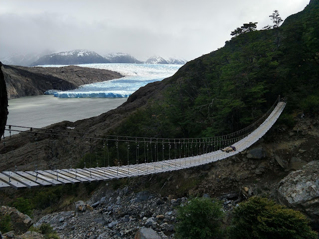
| The hanging bridges a little past Refugio Grey |
 |
| Taking a quick break |
 |
| It cleared up a bit as we walked back to our campsite |
On our fifth and last day, we took the option of walking out of the hike (instead of the boat that is owned by the same family as the private land and is super $$). The boat company actually made CONAF close this route going in and only allows people to walk out, which in essence forces visitors to take the boat at least once. Because of this, it is not very traversed. It was flat and we had a perfectly clear day. With the mountain range behind us we often turned back to see the whole range in all its beauty (not easily done along the 'W' itself). We did not see another person the entire time we were hiking and at the end of the hike Z was ahead and saw a puma from the road! A missed it and there is no photo proof, though others driving nearby confirmed the sighting.
 |
| They do not make it easy to find the trailhead out of the circuit |
 |
| UFO cloud |
Overall this hike was a highlight of our trip and was an incredible way to spend Thanksgiving (yes, yes, yes, we are super behind on posting). It was very difficult spending all day Thanksgiving Thursday discussing all the foods we would be eating, we would be making, what our family was eating, etc. and us ending up eating rice & beans (we also missed our families as well). We recommend this hike, and if anyone is trying to plan this feel free to contact us for more info on how we made our reservations but warning: it was a terrible 2 day process with lots of frustrations and completely required us to be there in person.
 |
| Views from the bus back to our car |
 |
| We hiked around these mountains! |
 |
| Family of Guanacos, momma pushing the baby along |
 |
| Salto Paine to end our visit to TdP |
To be consistent with past posts of our road trip, this leg of the trip was 9 days and maybe 200 km driving, but almost 100km (~60 mi) in walking...


Comments
Post a Comment